DAMOCLES data in google earth
open all in Google Earth ALL.kml or clik on the images to select individual layers.
The datatypes are:
-
TARA. Follow the drift of Tara in Google Earth with the latest AMSR-E and ASAR images<>
Open
TARA drift track
AMSR-E Passive microwave ice concentration
ENVISAT_ASAR Medium resolution ASAR image
Latest High resolution ASAR
<>
Open ALL
-
-
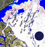
Total ice concentration image based on Microwave radiometer data from NASA and JAXA's AMSR-E instrument. The ice concentrations are colour coded using a grey-scale with higher ice concentrations showing up as white and lower concentrations as darker greylevels. I have some problems with the automatic generation of transparent gifs/pngs so some lower ice concentrations show up as faint colours. Normally the data are less than 24 hours old. The ice concentration algorithm is an optimal estimation algorithm that is much less sensitive to atmospheric noise than traditional ice concentration algorithms.
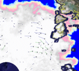
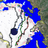
3-day ice drift vectors from Global Monitoring Mode data of ESA's ENVISAT ASAR
(Updated several times per day).
The dot identifies the location if the ice 3 days ago, and the other end of the line is the location of the ice today. Note that since this is a near real time dataset, you will see areas missing data early in the day and they will gradually get covered as satellite passes become available. The satellite data are supplied by ESA, and the data processing (ice drift retrieval using cross correlation) is carried out by DTU.
Note that there is an exaggerated version of the drift as well, where the drift lines are three times longer than the actual 3-day drif
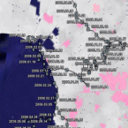
Location and drift track of the Russian North Pole 34 manned ice drift station since it's launch in September 2005 (Updated daily). Data supplied by the AARI (Arctic and Antarctic Research Institute) in St. Petersburg. -
Location of a number of drift buoys in the Arctic region. Most of these buoys are deployed as part of the International Arctic Buoy Programme (IABP). The IABP web page is maintained at the Polar Science Center, University of Washington. The locations are updated daily. Recently 4 tilt-meter/drift-buoys deployed in the GreenICE project has been added as well. 2 of these are now in the Baffin Bay. Drift since January 1, 2006 is shown as a coloured drift track attached to the buoys. -
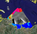
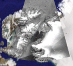
Nares Strait ENVISAT ASAR. A mosaic of the last 3 days ENVISAT ASAR Global Monitoring Mode data. The resolution is aproximately 1 kilometer. More sections will be added soon. Updated several times per day -
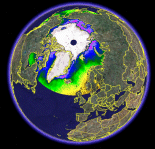
AMSR-E SST. Mean sea surface temperatures retrieved by the same optimal estimation algorithm as the total ice concentrations. The image shows a 7-day mean SST field. The original data are from NASA and JAXA's AMSR-E instrument. The SST image is updated several times per day. Note that the SSTs close to the ice edge may have errors, and that since the SST image includes data from 7 days, there may be some overlap of the SST and the ice concentration images. -
Driftstations
See the drift across the Arctic of Nansens FRAM and other stations in the past.
-
DAMOCLES provides a substantial step forward
DAMOCLES investigates impacts of climate change in the Arctic
Wikipedia on the DAMOCLES myth
The DAMOCLES myth
Technical University of Denmark
Ørsted-DTU
Other sea-ice pages at Ørsted-DTU

DAMOCLES is a european contribution to the International Polar Year 2007 - 2008.
- BACK
- the european space agency's
polarview
project
- Polarview at dtu
- DAMOCLES is funded by the European Comission under the 6th framework Programme.
-
-